Mapping the Moon with the Lunar Orbiter
Jul 15, 2025
If you are traveling somewhere new, you are more than likely going to need some form of map to get there.
In 1961, President John F. Kennedy gave the United States a mandate:
Before the decade was out, land people on the surface of the Moon and return them safely to the Earth (the astronauts always emphasized that last bit). Many logistical questions needed to be solved before this colossal task could be accomplished. One immediate need was a detailed map of the Moon.
Until the 1960s, high-resolution images of the Moon came from telescopes and could not capture the far side. The first photographic atlas of the near side had been completed only in 1904 by the astronomers of the Paris Observatory and was the result of 6000 telescopic photos of the Moon. A similar atlas was published in 1960 by US astronomer Gerard Kuiper. The Lunar Orbiter program, started in 1960 to place probes in orbit around the Moon for satellite mapping, offered an improved view, and access to the far side. In 1962 and 1963, the program was reconfigured to support the Apollo program.
File URL

Five Lunar Orbiter missions photographed both the near and far sides of the Moon in 1966 and 1967 to prepare for the Apollo landings. The first three targeted safe flat areas on the Moon’s near side. These were potential landing sites chosen through telescopic observations. The fourth and fifth missions flew in polar orbits, providing widespread coverage. They also targeted sites of scientific interest.
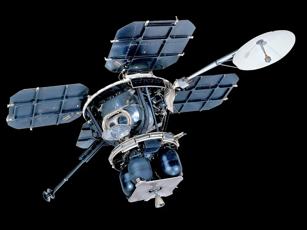
The most unique aspect of the Lunar Orbiters had less to do with why they were taking images of the Moon and more to do with how they were taking these images and sending them back to Earth. Rather than sending television images back to Earth as electrical signals, the Lunar Orbiter took physical photos of the Moon.

But how did they get the film back to Earth so it could be developed? They didn’t! Instead, the Lunar Orbiter carried its very own mini-film lab inside of it. The film was exposed through the Lunar Orbiter’s lenses like any other camera. Then the celluloid film was developed, dried, and scanned, all within the satellite. Finally, a tiny point of light scanned the film, creating digital information from the image. This information, converted into signals, was sent to Earth.

The photographic system on the Lunar Orbiter, while unique, was adapted from something perhaps even more unique—a secret spy satellite program called the SAMOS Project. SAMOS was the Air Force's rival program to Project Corona, a different secret spy satellite program run by the CIA. Orbiters used 70-milimeter cameras similar to those used on Corona and SAMOS spy satellites. The cameras had two lenses. This configuration allowed high and medium resolution images to be captured at the same time. (Unlike the Lunar Orbiter, Corona’s film buckets returned the exposed film to be collected by aircraft and developed on the ground.)
The Lunar Orbiters’ connection to spy craft doesn’t stop there. In order to use the images taken by the Lunar Orbiter to plan human landings on the Moon, NASA worked with professionals experienced in closely examining satellite imagery. In 1967, cartographers from the intelligence community who specialized in this type of map making created lunar orbit charts from Lunar Orbiter photography. Trained photogeologists in the Army Corps of Engineers also interpreted the Lunar Orbiter images.
In addition to the broad photographic coverage of the Moon, the Lunar Orbiters provided additional information that aided the Apollo missions. Sensors mapped the radiation levels around the Moon. Analysis of the orbits of the Lunar Orbiters found evidence that some areas of the Moon had a gravitational field that was stronger than expected. These anomalies suggested the Moon was not gravitationally uniform. Instead, it appeared as if buried concentrations of mass were under the large basaltic plains, called mare, on the lunar surface. By discovering and defining these "mascons," Lunar Orbiters made it possible for the Apollo missions to conduct highly accurate landings and precision rendezvous.

All five Lunar Orbiters successfully achieved their objectives. After depleting their film supplies, they were purposely crashed onto the Moon to prevent their radio transmitters from interfering with future spacecraft. They remain there today. All in all, the Lunar Orbiter missions mapped 99% of the Moon’s surface—an enduring legacy that lasts to this day.
This story was adapted from the Boeing Milestones of Flight Hall.
Related Topics


Related Objects
We rely on the generous support of donors, sponsors, members, and other benefactors to share the history and impact of aviation and spaceflight, educate the public, and inspire future generations. With your help, we can continue to preserve and safeguard the world’s most comprehensive collection of artifacts representing the great achievements of flight and space exploration.
Support the Museum
We rely on the generous support of donors, sponsors, members, and other benefactors to share the history and impact of aviation and spaceflight, educate the public, and inspire future generations. With your help, we can continue to preserve and safeguard the world’s most comprehensive collection of artifacts representing the great achievements of flight and space exploration.